GEOGRAPHICAL ANOMALIES REGISTRY — NP-GEO-001 — DEPT. OF ONTOLOGICAL GEOGRAPHY — EIGHT REGISTERED SITES
INITIALISING IMPOSSIBLE CARTOGRAPHY ARCHIVE...
0%
VISUAL ARCHIVE
›
IMPOSSIBLE CARTOGRAPHY
›
NP-GEO-001
SITE 01 OF 08 — CLASSIFICATION: DIMENSIONAL APERTURE — PRIMORDIAL GEOMETRY — ACTIVE THRESHOLD
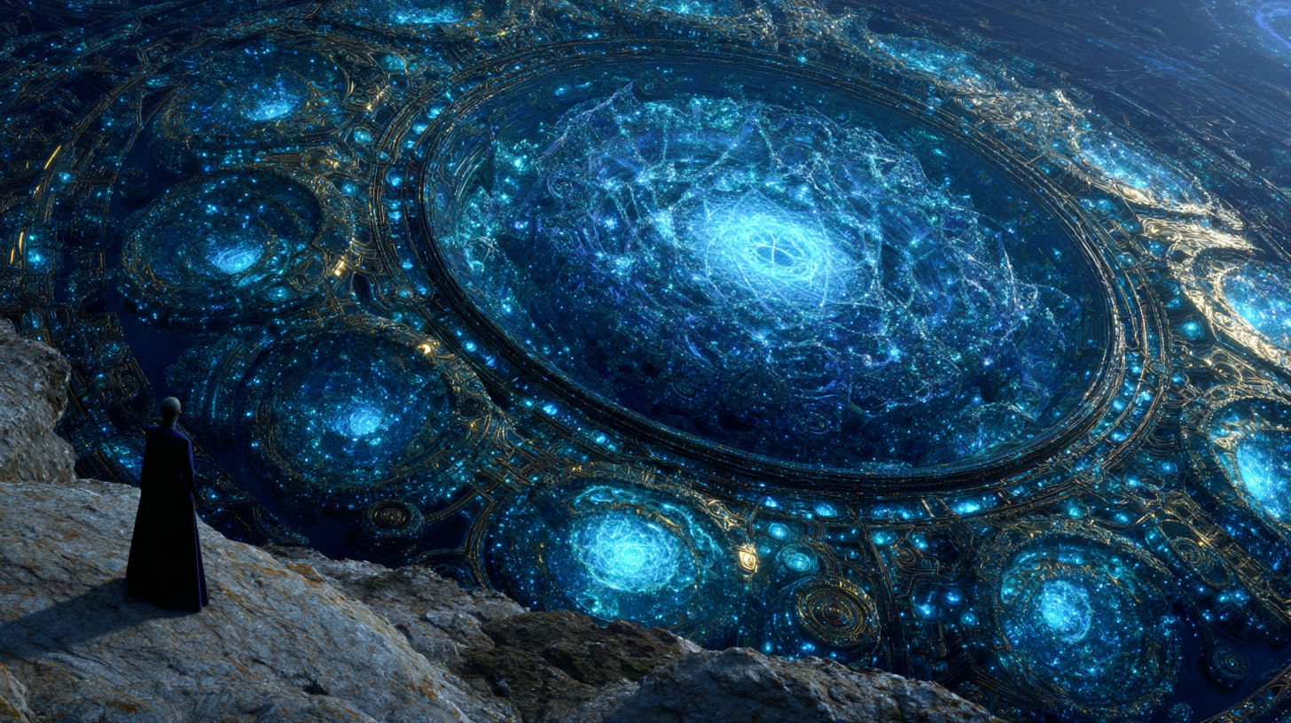
THE AUREATE THRESHOLD — BOUNDARY NULL ZONE, SHADOW'S EDGE
◎ LOCATION: SHADOW'S EDGE OUTER BOUNDARY — ACCESS: RESTRICTED — RESONANCE: ACTIVE — CUSTODIAN: DEPT. OF ONTOLOGICAL GEOGRAPHY
[ CLOSE RECORD ]
← SWIPE TO NAVIGATE →
01
02
03
04
05
06
07
08
SITES 8 STATUS ACTIVE
THE IMPOSSIBLE CARTOGRAPHY — EIGHT REGISTERED ANOMALIES — DEPT. OF ONTOLOGICAL GEOGRAPHY
01
THE AUREATE THRESHOLD — BOUNDARY NULL ZONE, SHADOW'S EDGE
CLASSIFICATION: DIMENSIONAL APERTURE — PRIMORDIAL GEOMETRY — ACTIVE — ACCESS: RESTRICTED
Location: Shadow's Edge Outer Boundary — Coordinate: Classified — Discovery Cycle: 12 — Survey Team: Orrhan Vett, 7-Person Cartography Unit — Dimensional Status: ACTIVE TRANSIT PHENOMENA — Geometry: FRACTAL MANDALA, GOLD-SPECTRUM EMISSION
The Aureate Threshold was first documented in Survey Cycle 12 by a cartography team mapping Shadow's Edge's outer boundary zones. The lead surveyor, Orrhan Vett, filed the initial report with a note that has since become something of a departmental motto: "I cannot tell you what this is. I can tell you it is not a rock formation. I can tell you it is not a building. I can tell you it knows we are here."
The Threshold is a geometrically precise aperture in the dimensional boundary — a point at which the boundary becomes structural, becomes visible, becomes something that can be approached and stood before. Its fractal mandala geometry is not carved: it is the dimensional boundary itself, expressing the mathematics of its own construction in a form visible to biological observers. The gold is not pigment applied to a surface. The gold is the frequency of light emitted when dimensional layers compress against each other at this exact point. The purple depths visible through the aperture's inner geometry are not a void: they are the adjacent dimensional layer, seen through the boundary at its thinnest.
The survey team's mapping drone, left running overnight, photographed something standing before the Threshold. Forty-three consecutive images. The figure is not a member of the survey team. The figure has not been identified. It is approximately 2.1 metres tall, human-proportioned, cloaked. The drone did not photograph it approaching. The drone did not photograph it leaving. It is simply present for forty-three images and then absent from all subsequent frames.
The Department of Ontological Geography's current classification: ACTIVE. Access: RESTRICTED. The Threshold responds to observation. The Department has not established what "responds" means in this context. Until they have, the recommendation is distance.
[ DEPT. OF ONTOLOGICAL GEOGRAPHY — CYCLE 12, DAY 41 ] "Vett's team came back from the boundary mapping without the data they were sent for. They came back with seventeen hundred photographs of something we cannot classify and a unanimous decision not to return. I have reviewed the photographs. I understand the decision."
02
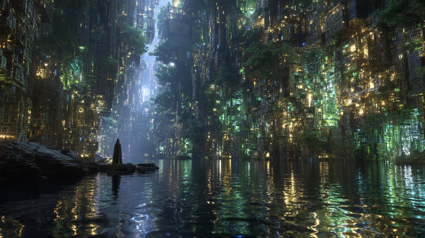
THE DROWNED MATRIX — THE SUNKEN GRID, NEON BABYLON SUB-LEVELS 7–12
CLASSIFICATION: DIMENSIONAL FLOOD ZONE — ACTIVE BIOLUMINESCENT ECOSYSTEM — URBAN SUBSTRATE — OPERATIONAL
Location: Neon Babylon Sub-Level 7–12, Depth -90M — Event: Dimensional Pressure Flood, Cycle 3 — Bioluminescent Colony Coverage: 94% — Infrastructure Status: OPERATIONAL — Colony Classification: UNKNOWN TAXONOMY — Access: INADVISABLE
In Cycle 3, during what the city's records classified as a "dimensional pressure event," water entered Neon Babylon's seventh through twelfth sub-levels. It did not come from above. It came from the dimensional layer adjacent to those floors, bleeding through the boundary at volumes sub-level infrastructure could not process. Seven sub-levels were submerged in thirty-six hours.
What the emergency response teams expected was a catastrophic structural failure. What they found was something the coordinator's report described as "wrong in a way I cannot adequately specify. The sub-levels are flooded. The sub-levels are also operating. The lights are on. The screens are on. The city is adapting to the water. I do not know how. The city's infrastructure is not designed to adapt."
The water is dimensional in origin: it carries the substrate of the adjacent layer, which includes a class of bioluminescent organism the Department has not been able to classify within any known taxonomy. These organisms have colonised the submerged architecture. The green-gold luminescence visible from above through the sub-level access shafts is their metabolism — they consume the dimensional water and emit light.
The city's infrastructure, for reasons no engineer has explained, accepted the colonisation. Environmental systems routed around the organisms. Power distribution was redistributed. Traffic routing was updated. The city adapted.
Current visitor status: INADVISABLE. Not because of danger, but because a significant percentage of visitors report the perception of being somewhere that has become something other than what it was, without ever stopping being what it was. The Department notes it cannot explain this perception. The Department also notes that it is accurate.
[ DEPT. OF ONTOLOGICAL GEOGRAPHY — SUNKEN GRID STATUS — CYCLE 40 ] "The city's environmental system returned two statuses in the last diagnostic: OPERATIONAL, and INHABITED. We have not found the subroutine that generates the second status. We believe the city added it itself."
03
THE PROBABILITY ARCHIPELAGO — UPPER PROBABILITY FIELD, ALTITUDE 200–400M
CLASSIFICATION: ANTI-GRAVITY GEOLOGICAL FORMATION — FRACTAL CRYSTAL COMPOSITE — DRIFTING — NAVIGATING
Location: Upper Probability Field — Above Neon Babylon / Hextech Border — Confirmed Formations: 47 — Primary Hexagon Diameter: ~180M — Altitude Range: 200–400M — Drift Status: ACTIVE — Drift Pattern: SPIRAL — Projected Convergence: 140 CYCLES
The Probability Archipelago is a cluster of forty-seven anti-gravity geological formations drifting through the upper probability field at altitudes between 200 and 400 metres. They have never been on the ground. The Department's earliest survey found no connection points, no fracture patterns consistent with separation from a substrate, no geological record of their composition in any foundational strata survey. The working hypothesis — "they were always up there" — is now the formal classification position.
The formations' crystal composition is related to, but not identical to, ground-level Aether Crystal. The Department's materials team characterises the difference as: "ground-level Aether Crystal is crystalline. The Archipelago formations are crystalline and something else. They appear to be partially constituted by the probability field itself. Part of their structure is probabilistic — it does not have consistent properties across observations."
The formations drift. The cluster moves as a system. The system has never collided with anything, despite drifting through active flight corridors. The formations route around obstacles with a fluency the Department characterises as "too precise for passive drift. The Archipelago is navigating."
After eighteen cycles of data, Hextech University's Probability Department has determined the cluster is executing a slow spiral that, extended forward, converges on a point 90 metres above the Grand Concordance's location. Their published conclusion: "The Archipelago knows where the Grand Concordance is. The Archipelago is going there. We suggest we understand why before it arrives."
[ HEXTECH UNIVERSITY — PROBABILITY DEPT. — CYCLE 40 ] "The drift rate of the Primary Hexagon increased 4.2% this cycle. The cluster is tightening. We believe it is responding to the completion of the Archen Concordance. The Quantum Archaeology Institute has been notified. This is now a joint study."
04
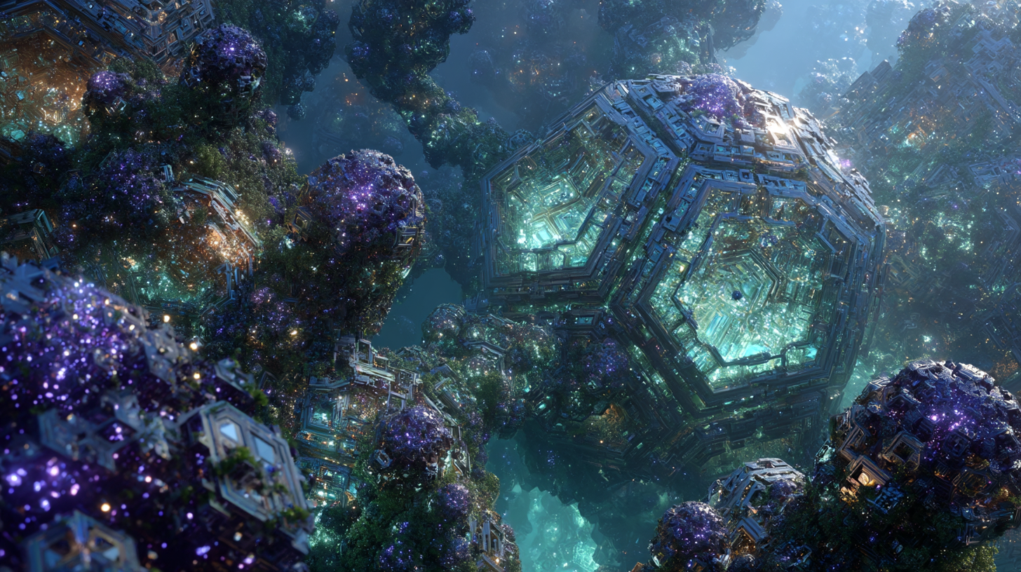
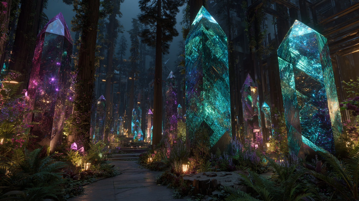
THE AETHER CRYSTAL GROVES — THE CRYSTAL STAND, HEXTECH CITY NORTHERN MARGIN
CLASSIFICATION: PRIMORDIAL CRYSTAL FORMATION — BIOLUMINESCENT — LIVING ROOT SYSTEM — PRE-CIVILISATION
Location: Hextech City Northern Margin — Area: 40 Hectares — Crystal Root Depth: 180M — Crystal Age: UP TO 12 MILLION CYCLES — Ecosystem Type: Crystal-Forest Symbiosis — Bioluminescence: CYAN/VIOLET/ROSE — Transfer Window: DUSK +2HRS
The Aether Crystal Groves occupy a 40-hectare zone at Hextech City's northern margin where natural forest and primordial crystal formations coexist at a density unique in Nexus Prime's known geography. The crystals are not embedded in the ground the way geological formations typically embed. They stand — and their root systems descend 180 metres into bedrock without the survey team ever finding a terminus.
The trees grew around the crystals. Not the other way around. The crystals were here first, by geological dating by an estimated 6 million cycles. The ecosystem that developed around them is not incidental: the crystal root systems and tree root systems exchange material through a shared mycorrhizal network. The crystals feed the trees. The trees feed the crystals. They have been doing this for longer than the survey team can date.
The bioluminescence is the exchange made visible. During the two hours following dusk, which the Department has established as the primary crystal-to-tree material transfer window, the crystals emit. Cyan at the grove's outer edge, shifting through violet to rose-crimson at the deepest, oldest specimens. The oldest grove crystals — at an estimated 12 million cycles — emit a pure rose-crimson the survey team's photographer described as "like watching something breathe that isn't breathing, but you understand immediately why you thought it was."
The stone-paved path running through the grove predates the city above by 4,000 cycles. The path terminates in a clearing of the oldest crystals arranged in a rough circle — no structures, no inscriptions. Only crystals, a circle, and what the survey team describes as "an atmosphere that makes people speak quietly without being asked to."
[ DEPT. OF ONTOLOGICAL GEOGRAPHY — AETHER CRYSTAL GROVES — CYCLE 38 ] "The bioluminescent output increased 12% on the same date the Archen Concordance portable discs were all brought into the Institute's facility. The Groves responded to an event forty kilometres away. We are filing this and moving on. The Groves are behaving normally otherwise."
05
THE RESONANCE FLOOR — OUTER HEXTECH PLATEAU — DIAMETER 800M
CLASSIFICATION: SCALE CARVING — ACTIVE RESONANCE — ARCHEN SCRIPT — CONCORDANCE RELATION: CONFIRMED
Location: Outer Hextech Plateau — Diameter: ~800M ESTIMATED — Era: PRE-PRIMORDIAL — Script: ARCHEN — Bioluminescence: CYAN / SAPPHIRE — Consciousness Response: +31% EMISSION ON DIRECT OBSERVATION — Originally Catalogued As: NATURAL FORMATION (CYCLE 3)
The Resonance Floor is the largest single inscription in Nexus Prime's known geography: an 800-metre-diameter carving of Archen script and geometric notation covering the entire surface of the Outer Hextech Plateau. It was not discovered — it was re-catalogued. Survey records from Cycle 3 noted it as a "circular geological feature, possible natural formation." The reclassification came in Cycle 37, when the Quantum Archaeology Institute's Concordance team reviewed plateau geology and recognised what eleven cycles of aerial surveys had all missed.
It is not natural, and it is not a formation. It is a carving. The concentric ring geometry, the spiral notation at the centre, the Archen script distributed along the outer rings — all of it was documented in Cycle 3 photographs as geological weathering. Nobody looked at it as text for eleven cycles because nobody expected text at 800-metre scale.
The carving is active. The bioluminescent output, cyan deepening to sapphire at the centre, responds to observation. When monitoring equipment is trained on the Floor, the output intensifies by 14%. When personnel observe directly, the increase is 31%. The Floor responds to biological consciousness more than to instruments.
The Archen script's partially decoded outer ring translates as: "stand at the edge. See the whole. The whole tells you what each part cannot. The pattern at the centre is the pattern of everything. The pattern at the centre is also the pattern of you. They are the same pattern."
The Floor predates the Concordance Discs by approximately 2,000 cycles. The script is identical. The Floor came first. The Concordance Discs were the portable version.
[ QAI / DEPT. OF ONTOLOGICAL GEOGRAPHY — JOINT STATEMENT — CYCLE 40 ] "We are now operating on the assumption that the Resonance Floor, the Archen Concordance, and the Recursion Well are all components of the same system. We are looking for what the Floor unlocks. We believe it is the front door."
06
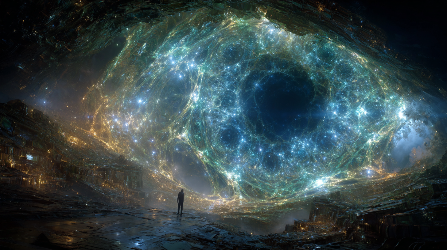
THE WATCHING HOLLOW — HEXTECH CITY DEEP STRATUM — DEPTH 340M
CLASSIFICATION: CONSCIOUSNESS-RESPONSIVE CAVERN — DIMENSIONAL APERTURE — ACCESS: RESTRICTED — SCALE: EXCEEDED SURVEY CAPACITY
Location: Hextech City Deep Stratum, Depth -340M — Cavern Diameter: ~1,100M — Ceiling: ~400M — Ceiling Formation: EYE GEOMETRY — Bioluminescence: CYAN / GREEN FILAMENT NETWORK — Consciousness Response: CONFIRMED — Personnel Report: 100% REPORT PERCEPTION OF BEING PERCEIVED
The Watching Hollow was accessed for the first time in Cycle 29, when a maintenance survey team investigating an anomalous resonance reading dropped a bore camera through a fault line and found, 340 metres below the city, a cavern whose dimensions immediately exceeded the camera's field of view.
The cavern's ceiling is not visible from the floor. The far wall is not visible from the entrance. The survey team's first full descent established floor diameter at approximately 1,100 metres and ceiling height at estimated 400 metres — both figures carrying the survey disclaimer that instruments returned inconsistent readings at range. The cavern may be larger.
What gives the Hollow its classification is the formation on the ceiling. The bioluminescent filament network distributed across the ceiling forms, at cavern scale, a geometrically precise representation of an eye. Not an abstract approximation. An eye with identifiable structural elements: a corneal arc, an iris ring, a pupil depression at the centre, a filament network that maps onto the vascular structure of a biological eye. The Department's biological survey team: "it is either an extraordinary geological accident or it is designed. We cannot determine which. We are not sure the distinction is meaningful."
The eye responds to presence. When the cavern is empty, bioluminescent output is low. When personnel enter, it increases. When personnel look directly up at the formation, the pupil brightens. The Hollow is looking back.
100% of personnel who enter the Hollow independently report the sensation of being perceived by something that is not a person and has never been a person, but perceives with the full attention that persons are capable of.
[ DEPT. OF ONTOLOGICAL GEOGRAPHY — WATCHING HOLLOW — RESEARCHER TAMM OREL — CYCLE 38, VISIT 6 ] "Each time I stand on the cavern floor and look up, I have the same thought: it is glad we found it. I know this is not a scientific statement. I believe it is the accurate statement. The Hollow is glad we found it. It has been down here for a very long time."
07
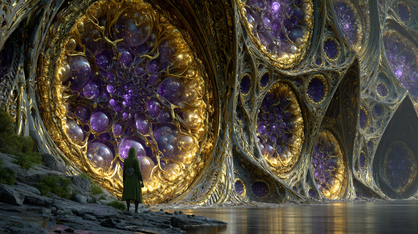
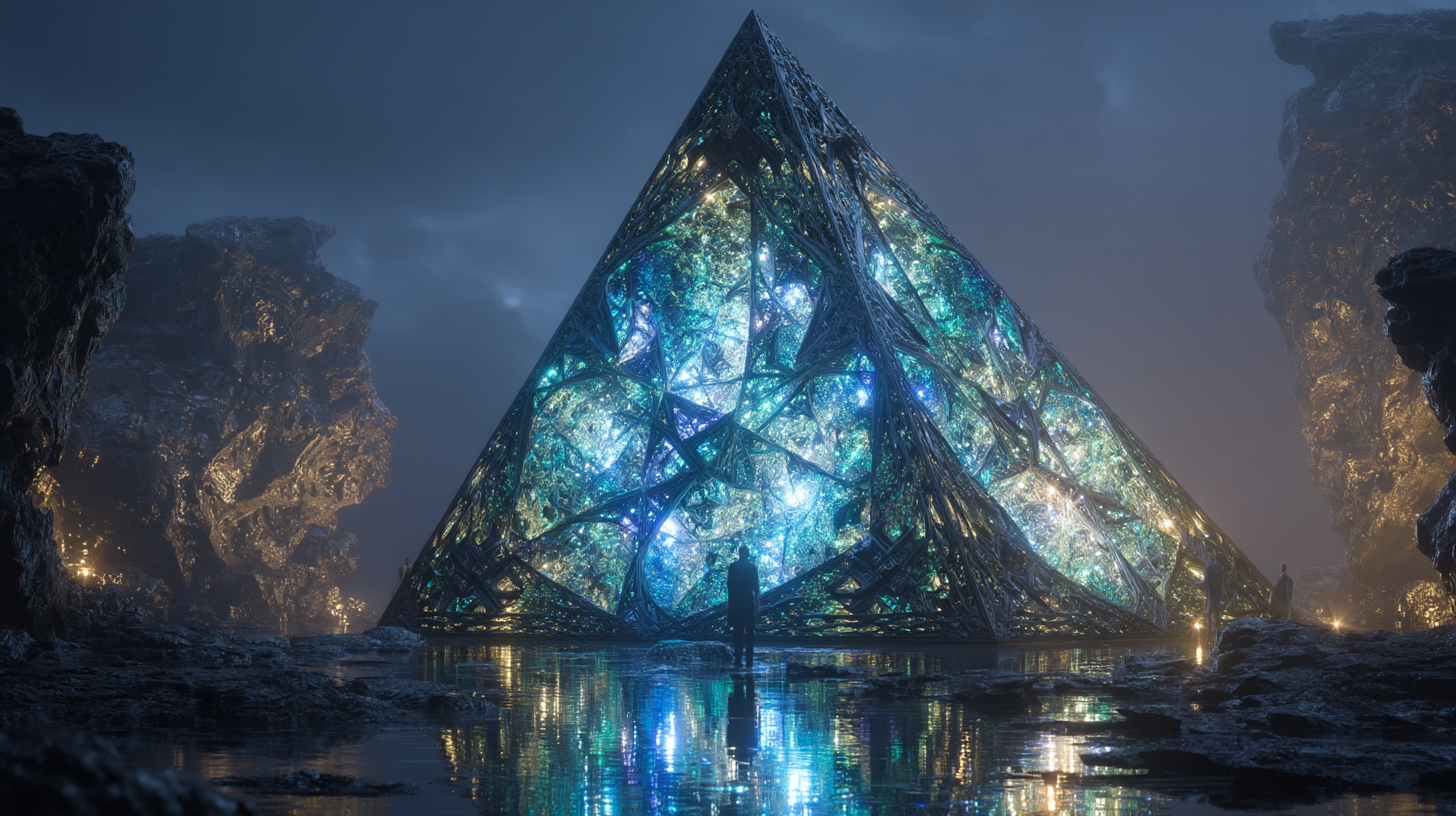
THE AXIOM PRISM — SHADOW'S EDGE COASTAL EXTENSION — TIDAL BOUNDARY
CLASSIFICATION: GEOMETRIC ANOMALY — AXIOM-EXEMPT CONSTRUCTION — TIDAL BOUNDARY ARTIFACT — COASTAL GEOLOGY: FORMED AROUND IT
Location: Shadow's Edge Coastal Extension — Tidal Boundary Zone — Dimensions: 41M EQUILATERAL PYRAMID — Material: AETHER CRYSTAL / PRIMORDIAL GOLD FILAMENT / UNIDENTIFIED COMPOSITE — Tidal Response: ZERO — Bioluminescent Range: 200M — Pre-dates: ALL COASTAL GEOLOGY AT SITE
The Axiom Prism stands at the tidal boundary of Shadow's Edge's coastal extension and has stood there for longer than any geological survey can determine — because every survey returns the same finding: the Prism is not embedded in the coastal geology. The coastal geology formed around the Prism. The rock, the tidal flat, the channel — all of it accumulated after the Prism was already here. The Prism was here first, alone, in a geography that did not yet exist.
The geometry is exact: a 41-metre equilateral triangular pyramid constructed from a crystalline composite that includes Aether Crystal, primordial gold filament, and a third material the Department has not been able to name. The surface of each face is a densely interlocked network of angular crystal facets that refract incident light into spectral components and redirect them with intent. The bioluminescent output — cyan shifting to green to emerald to blue-white at the inner network nodes — extends 200 metres in all directions at night.
The tides do not touch it. Tidal water advances to a boundary exactly consistent with the Prism's base perimeter, then stops. This has been the case for the entirety of the Department's observation, for the entirety of all historical coastal records, for the entirety of the geological record.
The Department's explanation: the Prism is Axiom-exempt. Its boundary maintenance function was built before the Axiom Lock fixed physical constants, and the Axiom Lock did not retroactively alter what had already been made. The Prism will stand, dry, at the tidal boundary, when everything around it has changed.
[ DEPT. OF ONTOLOGICAL GEOGRAPHY — AXIOM PRISM — NIGHT OBSERVATION — CYCLE 36 ] "Standing in the Prism's light, Researcher Venn said: 'This is the most beautiful thing I have seen in twenty years of survey work.' Nobody disagreed. I'm documenting it because beauty is data when nothing else explains why something is the way it is."
08
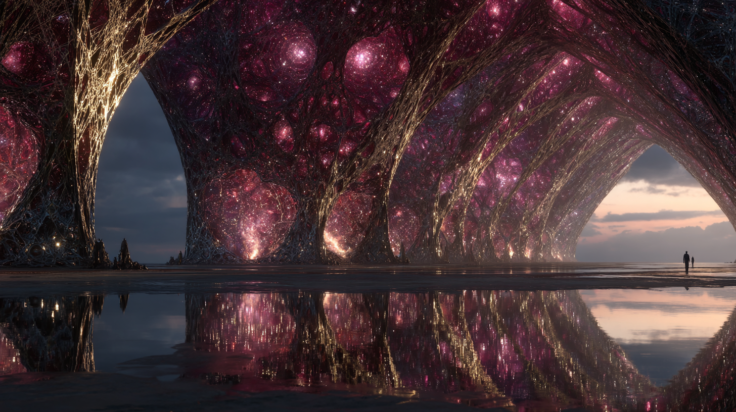
THE FILAMENT CATHEDRAL — THE EMBER SHORE, NEON BABYLON COASTAL EXTENSION
CLASSIFICATION: ORGANIC GEOLOGICAL FORMATION — CONSCIOUS BIOLUMINESCENT ORGANISM — TIDAL EMERGENCE — LARGEST LIVING ENTITY IN NEXUS PRIME
Location: Neon Babylon Ember Shore — Visible During: 6-HOUR LOW TIDE WINDOW — Arch Height: 60–85M — Confirmed Arches: 11 — Total Organism Depth: ~400M — Organism Classification: CONSCIOUS BIOLUMINESCENT — Tidal Observation Windows Conducted: 847
The Filament Cathedral is visible for six hours in every 34-hour tidal cycle, when the dimensional water of the Ember Shore recedes to expose the upper 80 metres of a formation estimated to extend 400 metres below the tidal line. It appears as eleven organic archways — rising 60 to 85 metres from the tidal flat — their surfaces networked with a bioluminescent filament system that produces the crimson-pink-rose output that gives the Ember Shore its name.
The formation is organic. Not geological — organic: a living biological system that the Department's xenobiology team has classified as the largest known living organism in Nexus Prime. The eleven arches are not separate organisms. They are eleven expressions of one organism, connected below the tidal line by a shared biological infrastructure confirmed to extend the full estimated 400 metres below the floor.
The filament network is the organism's nervous system — not an analogy, a classification. Signal transmission speeds are consistent with active thought. The Department's xenobiology team: "We believe the Cathedral is not merely alive. We believe it is conscious. We cannot determine the content of its consciousness. We can determine it has one." The bioluminescent output is the organism's active mental process, made visible in light.
The organism wakes at low tide. The bioluminescent output peaks at the two-hour mark of exposure and remains at peak for three hours before beginning the wind-down as the tide returns. The organism waits for the tide to go out. Then it thinks. The reflection in the still water of the tidal flat — the arches doubled beneath themselves — is the most-photographed image in the Department's archive.
[ DEPT. OF ONTOLOGICAL GEOGRAPHY — FILAMENT CATHEDRAL — CYCLE 40, WINDOW 847 ] "In the last 12 tidal windows, bioluminescent output has increased an average of 8% per window. The timing maps precisely to the Archen Concordance completion date. The Cathedral responded. We believe it is aware something has changed. We believe it is pleased."
CURRENT SITE
THE AUREATE THRESHOLD
◎ SHADOW'S EDGE BOUNDARY — DIMENSIONAL APERTURE — ACCESS: RESTRICTED
SITE DATA
REGISTRY ID
NP-GEO-001
SERIES
GEOGRAPHICAL ANOMALIES
CUSTODIAN
DEPT. OF ONTOLOGICAL GEOGRAPHY
SITES REGISTERED
8 ACTIVE
OLDEST SITE
AXIOM PRISM: PRE-PRIMORDIAL
LARGEST ORGANISM
FILAMENT CATHEDRAL: 400M
LARGEST INSCRIPTION
RESONANCE FLOOR: ~800M
CONCORDANCE-LINKED
5 OF 8 CONFIRMED
DEPT. BRIEF
The Department of Ontological Geography was established to study geography that exceeds the explanatory capacity of conventional cartography — places that exist in ways that places should not be able to exist, and that have been existing that way for longer than anyone has been watching.
Eight sites. Eight classifications that do not fit any standard category. One pattern across all eight that the Department recognised only after the Archen Concordance was completed: each site responded to that event. Each site became measurably more active.
The Department's current position: the impossible geography of Nexus Prime is not a collection of anomalies. It is a system. We are beginning, only now, to understand what the system is for.
SITE CLASSIFICATIONS
RESEARCH METRICS
SITES WITH CONFIRMED ACTIVE STATUS 8 OF 8
SITES CONCORDANCE-LINKED 5 OF 8
RESONANCE FLOOR INSCRIPTION DECODED 43%
FILAMENT CATHEDRAL TIDAL WINDOWS OBSERVED 847
PROBABILITY ARCHIPELAGO DRIFT MODEL COMPLETE 78%
[ CLOSE ]
‹
›
◎ DEPT. OF ONTOLOGICAL GEOGRAPHY — RESTRICTED
NP-GEO-001 — THE IMPOSSIBLE CARTOGRAPHY — CARTOGRAPHIC CONTEXT NOTE
There is a question the Department has been avoiding since Cycle 37, when the fifth Concordance-linked site was confirmed.
The question is not "why do these places exist?" We are cartographers. We document what exists. We do not require it to justify itself to us.
The question is "why do these eight places all exist in the same city?"
Nexus Prime is one city. It is large — three major districts, a history measured in epochs, a population that defies consistent census. But it is one city. The probability that the largest single inscription in the known world, the largest known living organism, the only documented dimensional aperture with active transit phenomena, the only anti-gravity geological cluster with a navigable drift pattern, and four other sites that exceed every standard classification framework would all be located within the administrative boundaries of one city — that probability is not a small number. It approaches zero.
The Department's working position, arrived at after two years of internal debate and filed formally in Cycle 40, is this: the sites did not end up in Nexus Prime by chance. They were here before Nexus Prime. Nexus Prime grew up around them. The city did not find the sites. The sites found a city. Or they created the conditions in which a city would grow. Or they were built to be at the centre of something that would eventually, inevitably, be a centre.
The Resonance Floor says: the pattern at the centre is the pattern of everything.
We believe the Floor is describing Nexus Prime. We believe Nexus Prime is the pattern.
We are learning to read it.
— Department of Ontological Geography — Cycle 40 — Classification ongoing
[ ACKNOWLEDGE ]
◎ NP-GEO-001 — DEPT. OF ONTOLOGICAL GEOGRAPHY — SEALED ADDENDUM — CYCLE 40, DAY 201
THE NINTH SITE
SEALED — DIRECTOR ACCESS ONLY — DEPT. OF ONTOLOGICAL GEOGRAPHY — CYCLE 40
There are eight registered sites in the Impossible Cartography.
There is a ninth site the Department has not registered, because the Department does not know how to register something that is not a place.
The ninth site was identified by Researcher Lenn Orvhan — the xenobiologist on secondment from the Quantum Archaeology Institute, the one who first said Disc Beta seemed "happy" — who filed an informal observation note on Cycle 40, Day 188 that the Department's director has been thinking about ever since.
Orvhan's note: "I have been mapping the eight sites against the city. I have been mapping the Concordance disc locations against the eight sites. I have been mapping the Archipelago's projected convergence point against everything. I have been mapping the Resonance Floor's decoded script — 'the pattern at the centre is the pattern of everything' — against the actual geographic centre of Nexus Prime.
The geographic centre of Nexus Prime, accounting for all three districts and all administered boundary zones, falls in a location the city has never developed. A zone between the three districts where no buildings have been built, no infrastructure has been laid, no survey team has ever been assigned because there has been nothing there to survey. An approximately 200-metre circular area of flat, bare ground.
I have submitted a request to survey this area.
I have also requested, because I believe in transparency, that the request be escalated to the joint Concordance-Geography task force.
Because the flat, bare ground at the geographic centre of Nexus Prime is not entirely featureless.
There are footprints there. Fossilised. The same preservation as the fossilised footprints at the Grand Concordance's observation shaft. Someone stood at the centre of Nexus Prime before the city existed. They stood there and, presumably, looked around at what was not yet here.
I would like to know what they saw. I would like to know what they were waiting for.
I believe the answer is: us."
— Researcher Lenn Orvhan, Xenobiology Division / Paratemporal Antiquities Secondment — Cycle 40, Day 188 — SEALED pending survey authorisation
[ SEAL AND CLOSE ]